
You are interested in drone photogrammetry and you don’t know where to start ? On the contrary, you are already a user of this measurement technique and you wish to deepen your knowledge and skills ? Then you’ve come to the right place !
How does the principle of photogrammetric reconstruction work?
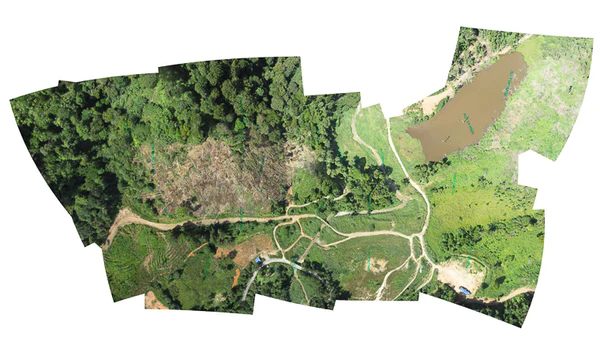
The principle of photogrammetry is a technique consisting in determining the dimensions and volumes of objects or spaces from aerial photographs. It is carried out in the form of a succession of “captures” in 2D or 3D from different points of view in order to ultimately obtain a projection of the scanned area.
This technology is useful in many areas. For example, it allows project owners to have an overview of an area or land with a view to carrying out work. This can also concern urban development and any other infrastructure that requires a detailed general view.
How is photogrammetry used with drone data ?
Drone photogrammetry is a precision exercise that requires careful preparation and good technical mastery of your camera. It is quite possible to calculate the time of a shot in advance or the number of batteries needed to perform a complete mapping.
The orthomosaic
It is the 2D modeling of the surface, from several aerial images, making it possible to visualize the site and to carry out precise measurements (surface, length). One of the recommended applications is the monitoring, before and after, of natural disasters, such as flood zones, landslides, forest fires.
Volumetry
Volumetry is an application of photogrammetry that makes it possible to create a 3D model of a terrain or stored volumes. This technique is mainly used in the mining sector, power plants, quarries or land management.
Comparable to 3D modeling, it makes it possible to extract cubages which are a volumetric measurement of materials as well as tonnages of a delimited space. The use of the drone makes it possible to carry out this work regularly due to its speed and low cost.
3D modeling
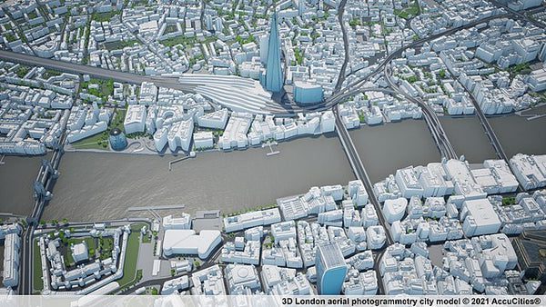
One of the uses of photogrammetry is 3D modeling. After taking aerial photographs, this technique consists of reproducing, using suitable software, computer-generated images representing the photographed scene in three dimensions. 3D modeling makes it possible to have a study support according to what is sought :
- the evolution of a relief (crevasse, cliff…) ;
- the implantation of a space such as a road or a watercourse on a chosen area ;
- the creation of an interactive model of buildings, facades or monuments ;
- 3D modeling of archaeological sites ;
- safeguarding heritage in order to freeze the state of a monument on a specific date.
3. Who uses photogrammetry ?
As discussed in Part 1 of this article, photogrammetry is used to capture all kinds of subjects, from people and historical relics to aircraft, buildings and even larger structures. Let’s take a closer look at a non-exhaustive list of industries that use this method :
Cartography
Photogrammetry is used for terrain mapping from photos taken using drones. It makes it possible to obtain high resolution images with great precision and in much faster times.
Photogrammetry allows taking vertical and oblique photos that provide an accurate image of the terrain, which helps in 3D mapping of an area. Aerial photography now makes it easy to access hard-to-reach areas to map terrain, including underwater areas.
Civil engineering
Photogrammetric techniques provide detailed information about the layout of the earth’s surface, which is of primary importance in the field of civil engineering. Thanks to the images and the 3D representation of the area, it is possible to carry out an accurate design.
Photogrammetric maps also help to establish urban development plans. They help to understand the terrain well so that roads and tracks can be planned accurately for easier and proper transportation.
Geology
Photogrammetry is a very effective way to determine soil types and layers. Thanks to the cloud of points generated by photogrammetry, it is possible to understand the shape of rocks, their formation and their composition.
Photogrammetry is often used to study the depth and assess the volume of lakes or rivers. It is also used in forestry to study vegetation and forest thickness.
Archeology
Photogrammetry provides an opportunity to map an area using historical photos to understand the structures and layout of an archaeological site. Aerial photography is commonly applied to map surface remains at excavation sites.
Photogrammetry offers a great facility for mapping maritime archeology compared to traditional methods.
Engineering
Engineering uses photogrammetry to monitor large structures. It becomes advantageous to use this technique because an unlimited number of points can be considered for measurements and can be processed automatically.
Photogrammetry is used because of its high accuracy, ease of use, and ability to take images under any conditions and from any angle make it an attractive option for engineering and structural monitoring .
Thanks to the great precision offered by photogrammetric techniques and 3D renderings, it has become much easier to evaluate a site and a construction project step by step.
Real estate
Real estate being a highly competitive market, the real estate industry uses the latest technologies to market and present the striking visuals of their properties. With the help of drones and photogrammetric techniques, real estate agents are able to obtain photographs taken from different angles with maximum precision. It is a cost effective method to allow the buyer to visualize and decide.
What are the advantages of drone photogrammetry and how accurate is it ?
Photogrammetric techniques provide very accurate results, making these measurements very reliable for mapping or other uses.
Photogrammetry provides a broad or expansive view of the mapped area using the topographic features of the surveyed surface.
The data collected is permanent and accurate and records the conditions that existed at the time the photographs were taken.
Since the information collected is permanent, it is much easier to re-survey or reassess the site to obtain the missing information without wasting time.
Thanks to the use of drones, it is easy to take pictures of remote areas and hard-to-reach places with precise measurements. It also reduces the threat to the safety of your teams surveying potentially dangerous locations.
When surveying roads with photogrammetry, photos and measurements can be made without disturbing the flow of traffic. Once the road characteristics are recorded, they can be used for planning future projects.
Which software or app to use for drone photogrammetry ?
Several software programs are now available free of charge, but their uses remain very limited. Nevertheless, you can find more paid versions at different costs for more or less optimal results.
Anxious to offer you relevant and effective solutions, we have chosen to work with the Pix4D software suite, in particular Pix4D Mapper. Why ? Because PIX4D is an image processing, photogrammetry, orthophotography and drone mapping development software that offers georeferenced and highly accurate maps for 2D or 3D modeling.
PIX4D is the ideal IT tool for professionals who want to perform analyzes or precise topographic studies in 2D, 3D modeling. PIX4D has the capacity to process thousands of aerial images in order to shape a 2D or 3D model. PIX4D has the capacity to process thousands of aerial images in order to shape a 2D or 3D model.
Pix4Dmapper automatically converts images, taken by drone, which provides very precise georeferenced 2D and 3D maps. They are customizable and complement a wide range of applications and software.
For professionals, the goal of mapping is not just to generate simple 2D orthomosaics and 3D models, but to create mapping that provides precise location and precise measurements.
From image capture to 3D modeling processing with Pix4D Mapper
Pix4Dmapper is a powerful software, which allows you to obtain from your drone the processing of georeferenced ortho-images and Digital Terrestrial Model (DTM). The images acquired by the drone are imported so that PIX4Dmapper can merge them.
Automatically, the software detects the georeferenced points of the surveys which may be incorrectly calibrated and helps you to process them to correct them. All the automatic functions are a valuable aid for removing objects, vehicles, buildings, vegetation from the georeferenced point cloud, allowing the creation of a DEM and contour lines.
The formation of the point cloud after processing will allow you a virtual exploitation of your images, maps and 3D works. The precision acquired thanks to the PIX4D software on volumes, cubature, precise distance measurements or virtual tours become easy to access, as well as the export of your files in formats.
Training, courses and method of photogrammetry, digital topography
Many schools offer training on the method of photogrammetry by moving from software operation to the use of different sensors. But before you commit, make sure that these training centers are credible and recognized. Some criteria to which you must be vigilant to ensure the credibility and quality of the training.
- School recognized as an expert in its field ;
- Accessibility to the latest technologies ;
- Support and field experience ;
- Availability of resources (advisers) once the training is completed ;
- Specialized training program: that responds precisely to your needs ;
- Recognized by public institutions.
Why choose DroneXperts for your training needs ?
Since 2013, DroneXperts has been the center of excellence and leader in the field of drone pilot training in Canada. Beyond providing simple training, you will have access to complete and tailor-made support.
Always on the lookout for the evolution of technologies and regulations, we have developed a set of training courses which aims to :
- Make you the elite of drone users in Canada ;
- Introduction to technology embedded in drones ;
- You bring the latest developments in regulations and technologies embedded in drones.
Our training courses are aimed at all people who wish to improve their skills or for all managers who wish to train one or more people internally.
DroneXperts specialists have more than 10,000 hours of experience in the field. You are therefore in good hands.
Whatever your current level of training, we have training courses that adapt to your needs.
If you want to learn more about our company, do not hesitate to consult our company page.
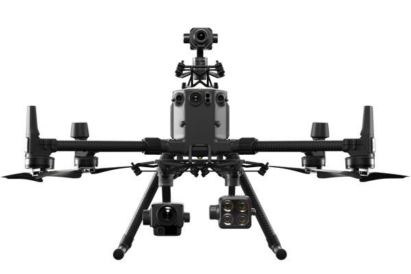
What is the best drone to buy for photogrammetry in 2022 ?
At first sight, you can do photogrammetry with different types of drone, but for a professional activity, the ideal is to target the right drone for the right mission.
Indeed, photogrammetry is only a method of calculations and measurements on orthoplans, previously constituted. These orthophotographs are constituted from photos taken by drone.
Before choosing the optics, it is necessary to know for which objective the orthophotography is built.
- If it is a point cloud with the objective of making precise measurements.
- If it is a simple visual inspection by Drone that allows easier organization of the data
RTK drones are drones equipped with a system called: “Real Time Kinematic”, which means in French: “Real-time kinematics”. In short, the error in the position provided by the satellites is corrected in real time.
This satellite positioning system is called GNSS from the English “Global Navigation Satellite System”.
Thus, each photograph taken by the drone equipped with this system ensures a precise position of the points then reconstituted.
The three most commonly used drones for photogrammetry are :
However, we can estimate that below 20 hectares, it is not necessary to fly with an RTK drone, the best thing being to correct its positions with GPS points taken on the ground.
Indeed, the Mavic 2 Pro makes it possible to carry out particularly precise orthophotographs. Once the data has been processed, it suffices to integrate GPS data to recalibrate the model. Scaling on Pix4D can also use ground measurements.
You have two options for setting points :
- Correction of the model by taking measurements on the ground ;
- GPS points taken: 5 points per hectare respecting altitude differences.
To sum it up like this: for large areas and for optimal use, the ideal is to have a drone equipped with RTK. For more limited work, a drone with a shot can allow you to have a very good quality rendering.
What are the important criteria for choosing your equipment (camera and sensor) ?
Whether you are a novice or a regular camera user, photogrammetry requires you to have a few notions that can strongly influence your results. Before defining which sensor you are going to use for your shots, it is important to take various parameters into account in order to obtain optimal image captures.
The resolution
This is one of the significant main characteristics as the differences in precision will be considerable. A high resolution (45 Mpx) will allow you to obtain ultra high definition captures with increased precision between pixels. Ultimately, the suggested minimum for doing photogrammetry will be 20 Mpx.
The focal distance
For photogrammetry, a wide-angle sensor is essential. Indeed, this will allow you to have a greater width of privacy. This data is generally expressed in millimeters and corresponds to the distance between the sensor and the optical center of the lens. In short, the shorter the focal length, the greater the viewing angle.
Geodetic precision
RTK (Real Time Kinematic) operation
The RTK drone with network subscription
The drone will communicate with reference stations (which are geographically distributed throughout the territory. These GNSS reference stations will indicate to the drone in real time which position corrections to apply to the georeferencing of the images.
In this way, the drone will geoposition each of the images acquired during the mission, with an absolute precision of the order of only a few centimeters.
This mode of operation requires :
- A subscription to an RTK network ;
- A SIM card with internet access.
The RTK drone with its base station
The drone will communicate with its base station. This station will be brought by the operator and positioned on the ground above a known point, in order to indicate to the drone in real time, what are the relative position corrections to be applied to the georeferencing of the images with respect to the known position on which the base is placed.
The base being positioned only a few hundred meters from the drone in flight, the precision of the corrections made will be very good. In this way, the drone will geoposition each of the images acquired during the mission, with absolute precision of the order of only a few centimeters as well.
This mode of operation requires :
- A base station.
PPK operation (Post Processed Kinematic or post-processed kinematics)
Some drones operate in PPK, i.e. the precision GNSS receiver will record the raw satellite observations received during the flight. On the other side, a base will also record local observation data.
At the time of acquisition, the images recorded in the drone are not yet precisely georeferenced (unlike the two techniques mentioned above).
After the acquisition sequence, it is necessary to assemble the raw data recorded by the drone as well as those recorded by the reference station in software which will act to transform the coordinates of each image to apply the position correction.
This mode of operation requires :
- A base station ;
- Software for PPK assembly.
Shutter speed
The shutter is an essential element for any camera. It is he who will allow the light to enter the sensor to save the photo, or on the contrary to block it. This part has long been mechanical, but many mirrorless cameras now incorporate an electronic shutter in addition to the traditional mechanical system.
The versatility of your drone
As several companies have a wide service offer, several sensors may be necessary to carry out all these projects. For example, some companies will do visual photogrammetry and/or thermal capture.
Normally, you have two options :
- Purchase of a drone with the ability to interchange sensors, which is not possible with all drones ;
- Buy several drones that you can use at the same time on different projects.
The scope of your projects
Depending on the size of your projects, drones such as Wingtra’s fixed wing can allow you to cover a larger area in less time compared to a quadcopter.
Transfer to a cloud (optional)
The ability to transfer your files directly to the cloud saves time by facilitating communication between field and office teams, but the latter remains optional.
Which sensor used for your photogrammetric surveys ?
As you will have understood, it is important to define your needs and your expectations in order to select the camera you wish to acquire in the best possible way. By reviewing a number of criteria, the DJI Zenmuse P1 camera stands out as THE ideal choice.
DJI Zenmuse P1 camera
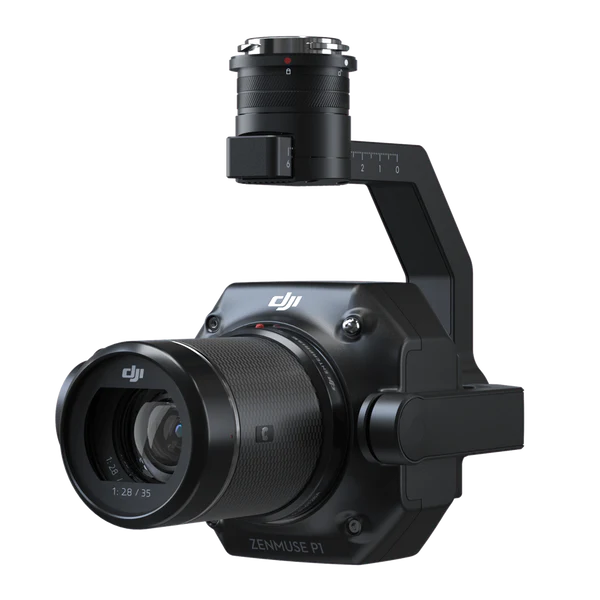
The Zenmuse P1 incorporates a full-frame sensor with 3-axis stabilized gimbal fixed-focus interchangeable lenses. Designed for photogrammetry missions, it takes efficiency and accuracy to a whole new level.
Mission results files are automatically associated with the name and time of the mission. Photos, GNSS data and files are stored together in a centralized folder. With this device, cover up to 7.5 km2 in one working day.
Increase the efficiency of your oblique photography assignments with the gimbal that automatically rotates to take pictures from the various angles needed. Only the photos essential to the reconstruction will be taken at the edge of the flight zone, which increases the efficiency of post-processing.
To conclude, the P1 camera is the most powerful camera from DJI. Equipped with a 45 MP full-frame sensor, this sensor provides very relevant results in photogrammetry or inspection. In automatic flight, the camera takes photos with an interval of 0.7s which optimizes mission times
How can DroneXperts help you with your photogrammetry needs ?
Before building a drone program, it is important to ask the right questions. We are here to guide you, from the analysis of needs to the organization and management of training, from the purchase of equipment to the planning of the maintenance program, up to the exploitation of your results.
The first step is arguably the most important, defining the benefits for your business. You can do this by reading a maximum of case studies that you can adapt to your vision.
DroneXperts can support you in several ways, whether to carry out and analyze your photogrammetry surveys. For example, we have been approached by companies who wanted to quickly assess the condition of building structures.
We were able to quickly identify their needs and deploy our drone for photogrammetry. We also participated in the aggregate volume assessment of a pit pit at the start and during the season.
We were able to precisely establish the volume extracted by an operator. The result: the volumetric calculation recovered nearly $200K in royalties. These two examples are part of a wide range of services that we offer to companies.
However, if you wish to acquire this technology, DroneXperts can also assist you in integrating drones and their technologies within your structure by following these 7 key steps :
Evaluate how using drones could save you time and money.
Our experts dedicated to your field will guide you in the possibilities of application and your choices of use
Establish your technology and application needs in the field.
Our technical advisers and advisers can help you in the choice of technologies (Brands, drones, accessories, transport boxes, battery management).
Acquisition, rental, or partnership.
You will need to allocate a budget for training, acquisition or rental of equipment, software. Our partnership will also allow you to assess the functions and the management time that you are going to offer to your staff.
Establish procedures and policies for using drones.
All programs have their own documentation, in compliance with regulatory standards and compliance. This ranges from the establishment of the operations manual, insurance to rules of conduct, incident management or the establishment of directives on the respect of customer privacy.
Choose your drivers who will be accompanied in the process.
The choice of people is not only based on their skills in your field, but also on their openness to developing other technical skills.
Train your pilots.
Training remains a major point for knowing and mastering the regulations of the country. You will have to respect the regulations of Transport Canada and all the internal rules that you will put in place.
Choose the people who will use your data and train them.
You could actually train additional staff, drivers and reporting officers. For example, the use of software such as Pix4D requires knowledge of Photogrammetry and 3D modeling.