
Drones: an innovative technology for the construction industry
In recent years, drones have become a valuable tool in the construction sector. They are revolutionizing working methods, bringing greater efficiency, lower costs and improved safety. Whether for topographical mapping, equipment monitoring or remote surveillance, the use of drones opens up new horizons. Let’s discover their potential and the best ways to use them in this context.
How are drones used in the construction industry?
The use of drones in the construction sector is extremely varied. These tools can be used to inspect construction sites, enabling real-time monitoring of work progress. They can also carry out highly accurate topographic surveys to help with project planning. Drones are also used for worksite surveillance, increasing safety by reducing workers’ exposure to potentially hazardous environments. Finally, they can be used to transport small equipment or materials on site, optimizing resource management. Drones are therefore versatile tools that can provide a real competitive advantage in the construction sector.
Drone applications for construction site inspection
Drones are particularly effective for inspecting construction sites. Thanks to their ability to fly at different altitudes and capture high-resolution images, they enable detailed inspection of structures under construction. They can be used to quickly detect any defects, from cracks on a façade to alignment problems on a structure, before they become serious problems.
- Visual inspection: UAVs equipped with high-resolution cameras can provide clear, precise images of structures, making it easier to identify anomalies or defects.
- Thermal imaging: drones equipped with thermal cameras can identify thermal insulation problems in buildings under construction.
- 3D modeling: Using photogrammetry, drones can create detailed 3D models of structures, helping engineers to visualize the project from different angles and detect construction errors.
- Inspecting hard-to-reach areas: Drones can inspect roofs, high facades or complex structures without endangering the safety of inspectors.
Using drones to inspect construction sites not only saves time, but also improves the quality and accuracy of inspections.
Drones for mapping and topographic surveys
The use of drones for mapping and surveying has revolutionized the way data is collected and processed in the construction industry. These devices can rapidly capture precise data over large areas, enabling the creation of high-precision 2D and 3D models.
Drones are used for topographic surveying, photogrammetry and 3D mapping. They are particularly useful for mapping difficult-to-access or high-risk areas. What’s more, using drones for topographic surveys saves considerable time compared with traditional methods.
In terms of technology, tools such as LIDAR enable drones to produce precise topographic surveys and 3D maps for a variety of construction applications. These tools offer unrivalled resolution and precision compared with traditional methods.
Geolocation is another essential feature of UAVs for mapping, reducing overall costs. The images collected by the drones can then be used to create precise digital models of the site using specialized drone mapping software.
In summary, drones offer many advantages for mapping and topographic surveying in construction, including:
- Fast, accurate data collection;
- Increased safety for workers;
- Precise modeling of construction sites ;
- Lower costs than traditional methods.
Using drones to monitor construction sites
The use of drones for worksite surveillance also offers many advantages. Their rapid deployment and ease of transport make them ideal for monitoring large areas in a short space of time. Equipped with GPS, the drone can easily return to take a photo from the same vantage point, enabling precise comparison of project progress.
The use of drones for site surveillance also helps prevent potential crimes, such as theft of construction equipment and materials. This enhances site safety and minimizes potential losses.
Finally, in addition to surveillance, drones are also used to communicate key issues to internal and external stakeholders, such as timing, layout, design changes and conditions encountered. This ensures better coordination and efficient project management.
The benefits of using drones in construction
Improving efficiency and reducing costs
The use of drones in the construction sector is helping to improve efficiency and reduce costs in a number of ways. On the one hand, these devices save time by quickly carrying out tasks such as inspecting structures, mapping sites or monitoring construction sites. On the other hand, they can help reduce costs by minimizing the need for expensive equipment or additional personnel for certain tasks. What’s more, drones can also optimize resource management by transporting small equipment or materials to the site. Last but not least, the data collected by drones can be used to improve project planning and management, thus avoiding unnecessary expenditure.
Choosing a drone for professional use in the construction industry
DJI: a benchmark brand for construction drones
DJI stands out as a brand of choice for construction drones. Founded in 2006, it is renowned for the technological innovation of its drones, equipped with sophisticated flight control systems and advanced sensors.
DJI develops drones capable of capturing high-resolution images for the creation of detailed 3D models, facilitating the identification, protection and preservation of heritage sites. DJI drones are also used for construction management, to monitor site progress, reduce risks and guarantee personnel safety.
Notable models include the Matrice range, which can be equipped with several high-performance sensors in a lightweight, portable body. This series is designed to improve the efficiency of drone operations, making it a preferred choice for users in the construction industry.
Criteria for choosing the best drone for a construction site
Selecting the best drone for a job requires careful evaluation of several essential criteria.
- Drone type: fixed-wing drones are ideal for topographical surveys, while quadcopters offer greater maneuverability for inspection and surveillance.
- Image quality: High definition is essential for accurate images during inspections or topographic surveys.
- Flight autonomy: A drone with a long flight autonomy can cover large worksite areas without the need for frequent battery recharging.
- Flying capabilities: A construction drone must be able to fly in difficult conditions (wind, high altitudes).
- Advanced features: Some drones are equipped with thermal sensors or LIDAR, which can be useful for certain applications.
- Respecting the rules: Make sure the drone you select complies with the rules in force in Canada.
Which drone for professional use?
The DJI Mavic 3 Pro
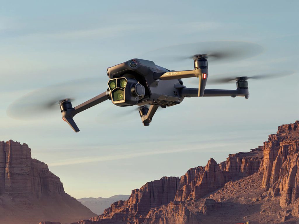
The DJI Mavic 3 Pro is a compact, foldable drone with advanced features that make it particularly useful in the construction sector. Equipped with a Hasselblad CMOS 4/3 camera, it offers outstanding image quality, making it easy to inspect and monitor construction sites.
On the one hand, its ability to provide detailed thermal images and videos is a major asset. The drone’s thermal camera system can detect sources of heat, such as structural weaknesses and damage.
The DJI Mavic 3 also stands out for its ease of use. Activating the drone, charging the battery and ensuring safety are simple processes, guided by clear on-screen instructions.
Finally, this drone offers a maximum flight time of 46 minutes and a maximum transmission range of 15 km, enabling extensive coverage of construction sites.
The DJI Matrice 350
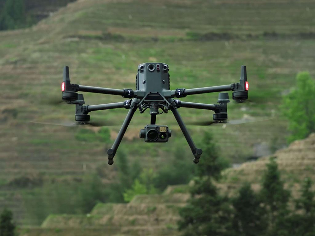
The DJI Matrice 350 is DJI Enterprise’s flagship drone platform, designed to meet the demanding needs of construction professionals. It features video transmission and control, a more efficient battery system and more comprehensive safety functions. This robust drone also boasts powerful propulsion and excellent flight performance, enabling it to effortlessly tackle a wide variety of challenges on construction sites.
The Matrice 350 boasts high payload and expansion capacities, with a maximum payload of 2.7 kg. It also boasts impressive flight autonomy, with a maximum duration of 55 minutes, offering extensive coverage of construction sites. In terms of imaging capabilities, the Matrice 350 is at the cutting edge of technology, offering excellent precision for mapping and 3D modeling.
Regulations governing the use of drones in the construction industry
When it comes to the use of drones in the construction industry, regulations are paramount. In Canada, Transport Canada regulates the use of drones under the Aeronautics Act and the Canadian Aviation Regulations (CARs).
Various rules apply, including :
- The obligation to register your drone and obtain a pilot’s certificate.
- A maximum flight height of 122 metres (400 feet).
- No flying near emergency sites or special events.
In addition, a distinction is made between drones (UAVs) and model aircraft, depending on the size of the drone and its use. For drones used in construction, it’s vital to maintain constant communication with air traffic control authorities.
It is also advisable to follow best practice guides, without replacing current regulations.
The future of construction drones
The future of drones in construction looks bright. Indeed, technological innovation and the rise of Artificial Intelligence (AI) are opening up a host of new possibilities. Drones could become essential tools in the construction industry, with ever more varied and high-performance applications.
The autonomy of drones is a major issue for their future use. Technological advances could enable these aircraft to make longer flights, increasing their surveillance and inspection capabilities on construction sites.
At the same time, the integration of AI into drones could revolutionize their use. The automation of tasks is a possible future prospect. In this way, drones could be programmed to carry out inspections, surveys or surveillance autonomously, without human intervention.
Last but not least, the future of drones in the construction industry could be marked by a boom in the use of drones to transport materials to construction sites. This drone function, as yet little exploited, could help optimize logistics on construction sites.
Drones therefore have considerable potential to transform the construction industry. However, it is essential to take into account the regulatory and safety issues associated with their use.
Training and skills required to pilot a drone in the construction sector
To pilot a drone in the construction sector, a number of specific skills and training are required. First of all, obtaining a drone pilot certificate is a legal requirement. This document is issued by Transport Canada and validates your ability to conduct safe and efficient drone piloting operations.
The DroneXperts training center offers a wide range of training courses, from initiation to more advanced flying. These courses focus on the theoretical and practical aspects of flying, but also cover subjects such as meteorology, navigation, aeronautics and photography.
Particularly in the construction sector, specific skills are required:
- Expertise in LiDAR technology, which enables precise topographic surveys;
- Knowledge of image processing software such as Pix4D mapper;
- Ability to conduct drone operations for structural inspection.
It’s also important to keep your skills up to date and specialize in specific areas through ongoing training. These training courses not only optimize drone use, but also ensure compliance with ever-changing regulations.
How can DroneXperts help you?
Drone support and integration
The DroneXperts center of expertise offers comprehensive support for integrating this technology into your construction operations. A complete service is offered, from drone sales to drone rental and training.
Our aim is to help you optimize the use of drones to maximize the benefits on your worksites. DroneXperts also offers personalized advice to help you choose the drone best suited to your specific needs.
Our services also include drone maintenance and repair, allowing you to concentrate fully on your construction operations. We’ll also help you set up an efficient drone data collection system tailored to your industry.
Last but not least, DroneXperts keeps up to date with Canadian drone regulations to ensure that your use of drones is completely legal.
Training
DroneXperts goes beyond simply selling drones. We are committed to providing you with effective training in the use of drones in the construction industry. Our training programs cover a variety of topics, from device handling to data collection and interpretation.
With DroneXperts, you have access to :
- Practical training in the field;
- Online seminars for flexible learning ;
- Workshops tailored to your specific needs.
Our experts will be with you every step of the way, making sure you get the most out of your investment. A pioneer in the sector, DroneXperts focuses on training to ensure the safe and optimum use of drones in your construction operations.